Introduction
In order to successfully use the ArcGIS Server REST API, you must understand how to construct a URL and interpret the response. All resources and operations exposed by the REST API are accessible through a hierarchy of endpoints for each GIS service published with ArcGIS Server. This tutorial should help you understand the REST API.
1. Determine the well-known endpoint
When using the REST API, you must know the well-known endpoint, which represents a server catalog.
For ArcGIS Server, the default endpoint is:http://<host>/<site>/rest/services/<folder>/<serviceName>/<serviceType>
Where:
http://<host>is the ArcGIS Server host name./<site>is the site name. The default value is"/arcgis/". ArcGIS Server accepts site name specified in a URL as lower case (arcgis) or a camel-case(ArcGIS). Using an all lower case site name is the recommended option.rest/services: This indicates the REST services endpoint. You will see a list of all services in the root directory along with any folders. This part of the URL is case-sensitive and should be specified in all lower case./<folder>: When the URL endpoint is to a folder, you will see a list of all services included in this folder. Folder names are case sensitive and should be specified in the case as it was created./<serviceName>/<serviceType>: This represents the name of the service and its type (eg: PopulationDensity/MapServer). Service Name is case sensitive and should be specified in the case it was created. The service type should be always specified in a mixed case format as defined for each service in the REST API reference(eg: MapServer, GeocodeServer, GPServer)
As an example, to get to the root directory of Sample Server 1 on ArcGIS Online services, the URL is:
2. Navigate using Services Directory
When you type in a URL endpoint in your browser, you will see Services Directory. Each ArcGIS Server comes with a Services Directory, which provides a way for you to navigate through the list of services, folders, and operations on a server.
- If you are unfamiliar with Services Directory, you should read the Services Directory overview.
- Navigate through the different folders and services on Sample Server 1, and see how the URL changes as you navigate to different pages. Note that the folder and service names in the URLs are case sensitive.
3. Understand the documentation
The REST API documentation has topics on all resources and operations as well as some introductory and reference topics. The hierarchy of resources and operations listed in the table of contents matches the hierarchy of the API itself. Each topic contains a description, URL parameters and examples, and JSON object response examples and explanations.
- The top node is Catalog.
- Under Catalog, you will see each of the service types such as Map Service and Geocode Service.
- Under the service types, you will see operations and child resources associated with a service type. For example, a Map Service has Export Map and Identify operations, among others. You will also see the Map Tile child resource.
4. Create a URL and see the response
When using the REST API, you need to construct URLs. Services Directory can help you generate URLs that include both the reference to a resource and any parameters. A URL with parameters will have the following syntax:
http://<resource-url>/<operation>?<parameter1=value1>&<parameter2=value2>
Where:
http://<resource-url>is the URL to a given resource. If the resource is a Server Object Extension or a Geoprocessing Service Task, the resource name is case sensitive.<Operation>represents the name of an operation supported on a resource. The operation name is not case sensitive, but you are recommended to use the operation name as specified in the REST API.?denotes the beginning of a parameter list.parameter1=value1is a name-value pair. The parmater values are case sensitive if the value is JSON or enumeration.
Almost all resources have an f parameter. This parameter determines the output format. For more information, you should review Output Formats.
To retrieve information about a Map Service in a JSON object, you would use a URL similar to the following:
The response is in JSON format and looks similar to the following.
{"serviceDescription":"This service presents various population statistics from Census 2000, including total population, population density, racial counts, and more. The map service presents statistics at the state, county, block group, and block point levels.","mapName":"Layers","description":"This service presents various population statistics from Census 2000, including total population, population density, racial counts, and more. The map service presents statistics at the state, county, block group, and block point levels.\n","copyrightText":"US Bureau of the Census: http://www.census.gov","layers":[{"id":0,"name":"Census Block Points","parentLayerId":-1,"defaultVisibility":true,"subLayerIds":null},{"id":1,"name":"Census Block Group","parentLayerId":-1,"defaultVisibility":true,"subLayerIds":null},{"id":2,"name":"Counties","parentLayerId":-1,"defaultVisibility":true,"subLayerIds":[3,4]},{"id":3,"name":"Coarse Counties","parentLayerId":2,"defaultVisibility":true,"subLayerIds":null},{"id":4,"name":"Detailed Counties","parentLayerId":2,"defaultVisibility":true,"subLayerIds":null},{"id":5,"name":"states","parentLayerId":-1,"defaultVisibility":true,"subLayerIds":null}],"spatialReference":{"wkid":4269},"singleFusedMapCache":false,"initialExtent":{"xmin":-185.337909350544,"ymin":-19.11255617006,"xmax":-59.5254875059344,"ymax":108.400033537315,"spatialReference":{"wkid":4269}},"fullExtent":{"xmin":-185.337909357176,"ymin":15.2049923316373,"xmax":-59.5254874993028,"ymax":74.0824850356176,"spatialReference":{"wkid":4269}},"units":"esriDecimalDegrees","documentInfo":{"Title":"USCensus","Author":"serverxadmin","Comments":"","Subject":"","Category":"","Keywords":""}}
In another example, you can request to export a map. In this case, you would use the a map service export operation. For this operation, you need to include the "bbox" parameter. Some parameters are optional and some are required. These requirements are noted in the documentation. An example URL is:

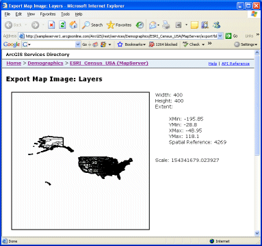
The above URL returns the response in HTML format, and you see an image along with its width, height, extent, and scale. If you want the same information returned in a JSON object, you need to include the f parameter:
http://myserver/arcgis/rest/services/maps/world/MapServer/export?bbox=-197.99999664046,-131.792384313038,197.99999664046,125.388423131397&f=json
The response looks similar to the following:
{"href":"http://sampleserver1.arcgisonline.com/arcgisoutput/_ags_map77043d465f5547f09c5b.png",
"width":400,"height":400,"extent":{"xmin":-195.85,"ymin":-28.8,"xmax":-48.95,"ymax":118.1,"spatialReference":{"wkid":4269}},
"scale":154341679.023927}
pjson. This option should only be used for debugging purposes since it takes longer to process the response.
{
  "href" : "http://sampleserver1.arcgisonline.com/arcgisoutput/_ags_mape8e1ca53a24a477380c7c9940e7b073d.png",
  "width" : 400,
  "height" : 400,
  "extent" : {
    "xmin" : -195.85,
    "ymin" : -28.8,
    "xmax" : -48.95,
    "ymax" : 118.1,
    "spatialReference" : {
      "wkid" : 4269
    }
  },
  "scale" : 154341679.023927
}
5. Use Services Directory dialog boxes to generate parameter values in the URL
Services Directory includes dialog boxes for all operations valid with a resource. These dialog boxes allow you to input values for URL parameters for testing purposes. In the response, you will see both the results and an encoded URL.
As an example, take a look at the "find" dialog for a USA service on sampleserver1.
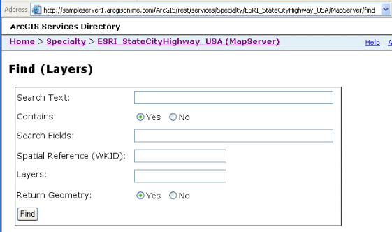
When you enter this URL or navigate to this URL in Services Directory, you will see the following dialog:

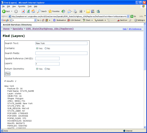
Each field in the dialog is one of the URL parameters for the find operation. The Find topic contains example values that are valid for each parameter. In the following example, a find operation is made on a states layer in the USA map service. The searchText is "New York". Only layer 1 (states) is searched, and the return geometry is requested. The find results are returned in an HTML format.

You should also take a look at the URL that was generated. The values you entered into the dialog box as parameters in the URL.
http://sampleserver1.arcgisonline.com/ArcGIS/rest/services/Specialty/ESRI_StateCityHighway_USA/MapServer/find?searchText=New+York&contains=true&searchFields=&sr=&layers=1&returnGeometry=true
Many characters in the request must be encoded in the URL. Encoding replaces certain special characters with hexidecimal values. Services Directory (being a brower based application) encodes URLs, but you will need to do your own encoding in your application. The following example shows a URL where many spaces, commas, curly brackets, colons and other characters have been encoded.
http://myserver/arcgis/rest/services/maps/world/MapServer/identify?geometryType=esriGeometryPoint&geometry=%7Bx%3A+-104%2C+y%3A+35.6%7D&sr=&layers=&tolerance=&mapExtent=-104%2C35.6%2C-94.32%2C41&imageDisplay=600%2C400%2C96&returnGeometry=true
Note that unless otherwise stated, the URL examples in the REST API documentation will be shown in their unencoded form for better readability.
6. Understand options for sending long JSON objects in a request
When using the REST API, you will normally use an HTML GET method in a form. When you use GET, the entire request is encoded in the URL. This is the preferred method to use whenever possible. However, in this mode, a URL is limited to as few as 1024 characters depending on the browser. Thus, if you have a long JSON object to include in the request, you will need to use POST.
A second option, when using certain Geometry Service and Geoprocessing Service operations, is to continue to use GET and to specify a URL to the input JSON object contained in a file on a public server.
Syntax: geometries={ "url" : "<URL to file>" }

Example: geometries={ "url" : "http://myserver/mygeometries/afile.txt" }


http://myserver/arcgis/rest/services/Geometry/GeometryServer/project?inSR=4326&outSR=54004&geometries={ "url" : "http://myserver/mygeometries/afile.txt" }